Owned and run by Barry Pengelly, Cornwall Discovery offers guided sightseeing tours in this beautiful and history county appreciating a wide range of wonderful attractions.
Barry was born and has lived in Cornwall for all of his life and is very passionate about shorting what it has to offer.
Find out more about Cornwall Discovery at www.cornwalldiscovery.co.uk
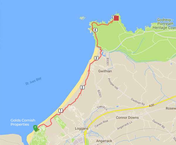
8 miles
Difficulty: Easy
The magnificent walk from Hayle to Godrevy Lighthouse takes in walking on the beach or dunes.
Probably the most photographed lighthouse in the World, Godrevy Lighthouse sits on a rock island in the sea and was made famous in a novel by Virginia Woolf "To the Lighthouse".
Your walk can start and end at (seasonal) beach cafés. The Cove Café on Hayle beach and Godrevy beach café both offer a range of food and drinks to satisfy any hardy explorer.
Starting on the beach at The Cove Café, simply head along the beach with the sea to your left. Soon the path enters a huge area of sand dunes.
The coast path here, follows various wooden posts marked with yellow arrows in the dunes, which seemsto keep randomly heading away from the coast.
Local recommendation is simply take on of the well-walked paths that follows as close as possible to the coast and you can't go wrong.
Soon you pass the Beachside Holiday Park in the dunes to the right.
Continue passing another holiday park and the Shore Surf School on the right.
The path keeps ahead into a more worn area of the dunes and the official route again heads a little way inland from the beach.
If you are walking along the beach you may wish to return to the official way-marked route here, depending on the state of the tide.
Prior to this there is always sand even at high tide but a little north of here the beach is completely covered around high tide so if you are not sure or if the tide is coming in, take to the coast path again, as the sand dunes on the right soon give way to low cliffs, making it harder to join the official route.
Follow the wooden posts through the back of the dunes and again if in doubt keep to a path close to the coast through the dunes.
Soon the path continues through the dunes on top of the low cliffs and you keep to this until you reach a car park, this time Gwithian Towans.
Continue through the car park on the cliff top as it descends back down to the beach level. Here you have another excellent beach backed by a mixture of dunes and various little ponds.
The beach has some shingle and pebbles at the back of the beach. If you are using an Ordnance Survey Map at this point there is an inconsistency in that the Orange covered Explorer map shows the coast path following the high tide mark, whilst the pink Landranger map shows the route as heading inland here to the road and following the road for nearly half a mile. Don't do that, but instead follow the beach at the high tide mark.
As you reach the cliffs at the north end of the beach there is a stream running over the sand to the sea with cliffs beyond. Turn right just before this stream and follow along it's edge with the stream on your left to a footbridge which crosses it and then once over the stream, turn left and then follow the track up the cliff to the National Trust car park and café .
On reaching the car park turn left and follow the road leading from the car park as it heads left back to the cliff top. The coast path generally follows this minor road (although there is a brief section on the left you can leave the road), but it's a very quiet road as it only leads to a car park.
Just past the car park you have the beautiful Godrevy Cove to your left and can enjoy fine views all around St Ives Bay and back to St Ives itself.
At the south edge of this beach the road turns to the right - do not take this but continue straight ahead on the coast path. This heads out onto Godrevy Point the very north end of the bay with Godrevy Island, with it's lighthouse just off the coast.
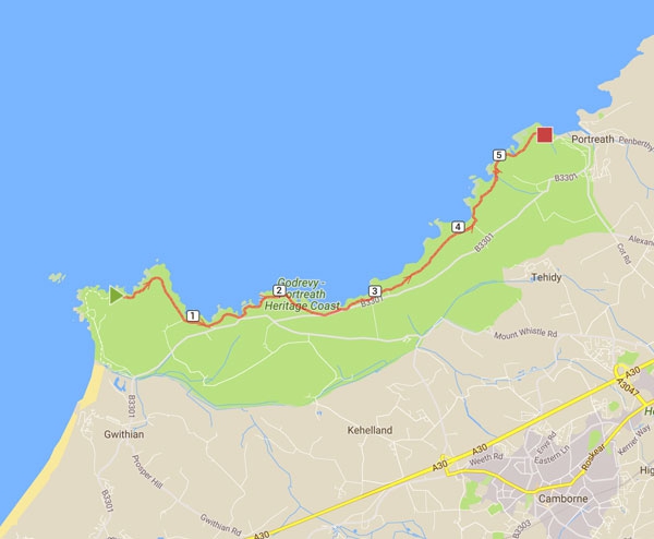
Difficulty: Easy to Moderate
The walk to Portreath is now along the cliff top passing mostly rocky beaches.
After rounding the head you have the small cove of Mutton Cove to your left although there is no access to the beach.
Keep to the obvious cliff top path now heading east. At the next headland, Navax Point the coast path is the wider of the two tracks and the more inland of the two tracks and it's recommended to keep to the official route here as the other paths tend to stop and leave you having to head through heather and gorse.
Once round the headland the path keeps to the coast as you turn to head south and passing two lovely sandy beaches, Castle Giver Cove and Fishing Cove although there isn't access to either from the coast path, sadly.
Keep to the now wider track along the cliff top.
For the next couple of miles the coast follows very close to the B3301 road that goes along the coast and there are several cliff top car parks off this road.
There is also a bus service during the summer that goes to St Ives (via Lelant) if you wish to cut the walk short and also to the end of the walk at Portreath although it is not very frequent.
Just after the second beach (Fishing Cove) the path forks, take the left most fork (the right most heads to the car park and road). Follow this path around the cliff top and back to the road where there is another car park just to the right.
This is Hells Mouth, a famous beauty spot on this spectacular part of the coast and you have fine views to the rocky cliffs below.
Continue along the obvious coast path along the cliff top as it crosses Hudder Down and soon runs very close to the road. There are several car parks along the cliff top here and part of the coast path has even been designated as a wheelchair usable path for one stretch.
After you pass the fourth of these small car parks on your right the road heads a little away from the coast and you continue on the obvious coast path along the cliff top.
You pass Greenbank Cove on the left, that has some sand at low tide although again there is no access to it from the coast path.
Continue past Crane Islands, a couple of rocks just off the coast and round to Basset's Cove, where there is another cliff top car park. This is another sandy beach at low tide and unlike the other beaches access is possible to it, although it's not especially easy and not really recommended.
Follow the path from the back of the car park and turn left to rejoin the cliff top. You soon have a very steep descent down to Carvannel Downs where you descend down the steep valley and then back up the other side. The path zig-zags for a time until you reach the top of the hill and then continue on the cliff top path to another good beach, Western Cove, with lots of rocks just off the shore. There is however no access to the beach.
Continue round the coast path behind the beach and ahead you can see that you've now arrived in the little village of Portreath where the walk ends. The path brings you out onto Battery Hill. Here you can turn left for access down to the beach or continue along Battery Hill, the road going to the right which will bring you to the main beach car park, where the walk ends. To the left is the fine sandy beach of Portreath whilst to the right is the main village centre.
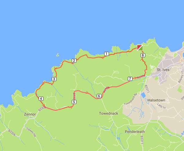
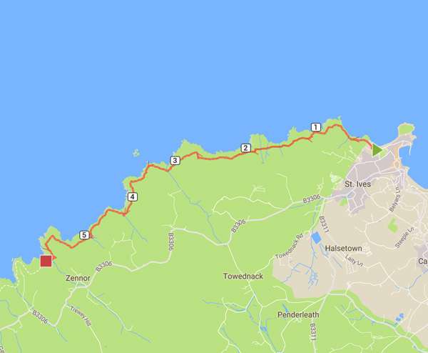
8 miles
Difficulty: Moderate to Severe
This walk is only for experienced walkers and will take 3 to 4 hours to complete. Although the first half of the walk is more moderate along the cliff path, some of the walk, in particular the later parts, are more difficult, with the path rising steeply from the coves to the cliffs, and with a few rocks to be navigated across here and there.
The walk is well worth the effort as the views are spectacular and the walk is rich in wildlife and historical interest, taking you to areas of the coast that are not normally accessible by any other means.
As there are no towns or villages along the route, and with little mobile phone reception around the cliffs, please make sure that someone knows where you are and when you are expected home, and don't forget to take appropriate walking gear, bad weather clothing & drinking water.
The path starts at Porthmeor Beach in St Ives heading out past the Bowling Green to Clodgy, and is well marked and relatively easy to follow.
Shortly after passing Clodgy point, you may notice the old ruins of a building on the seaward side, which is the old leper colony established there giving it's name to Clodgy point with the Cornish for 'klav' and 'ji' meaning 'sick house'.
The path continues then to rise past the cliff tops and descends towards the many coves you will pass. On the way you will see the Carracks or Seal Island as it is known locally, and may well see the boat trips from St Ives stopping there for visitors to watch and feed the seals.
Nearing the end when you reach Zennor Point, it is tempting after your recent steep climbs to take the short cut left over the headland to the village. However if you do you will miss out on the last part of the coastal path, which takes you up to Trig point to enjoy the final views, before following the path up the valley to Zennor.
Before taking the bus back to St Ives, enjoy a well earned pint at The Tinners Arms.
Legend has it that if you sit above Mermaid Cove at twilight on a summers evening, you might just hear the singing of a man who fell in love with the mermaid of Zennor and followed her out to sea. We can't vouch for whether this is true, but couldn't say that it isn't either; so do let us know if you hear anything.
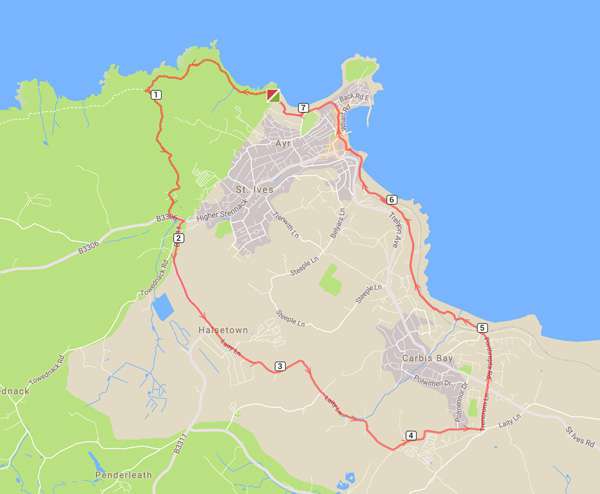
4 miles
Difficulty: Easy
This is a relatively easy walk from St Ives harbour, taking you along Hain walk towards Carbis Bay, and then heading up The Belyars, around the top of St Ives, before heading back to Porthmeor and returning to the harbour.
Starting at St Ives harbour, head to the Lifeboat house and follow the path beside the lifeboat house keeping the sea to your left towards Porthminster beach.
After passing Porthminster continue to climb up the path crossing the railway line coming out at Hain Walk after the steep section at the top.
Continue straight ahead following Hain Walk, passing the Baulking House where they used to keep a look out for the pilchard shoals.
After approximately half a mile, while heading downhill towards Carbis Bay beach, take the right hand fork in the path heading uphill and through the kissing gate.
Continue on until you reach the main St Ives Road, and turn right heading into St Ives for approximately 200 yards to The Cornish Arms pub.
Cross the road here & turn up Higher Tregenna Road beside the Cornish Arms (not the narrow Steeple Lane that is immediately left again).
Head up towards St Ives School noting Knills Steeple on your left.
Continue straight on past the school through a wooden & metal gate & down the lane past the golf course.
At the T junction turn right then quickly left up Trenwith Lane heading towards the Belyars Bowling Green. Follow this windy country lane for approximately half a mile eventually passing houses on the left.
Continue straight on past St Ives Veterinary Surgery keeping the Vets on your right down to the main road. Go over the pedestrian crossing turn right down the hill then quickly left to follow the road signposted to Porthmeor Beach car parks & Tate St Ives.
Follow this road as it zig-zags back towards Porthmeor, eventually heading down Porthmeor Hill to the beach and then continue on past The Tate Gallery.
Follow the road as it turns away from the beach and follow it left at Bumbles Tea room, past the Porthmeor Studios to St Ives School of Painting.
Just a little way past and opposite the St Ives School of Painting turn right into Norway Square, and zig-zag back to the harbour to complete the walk with a well earned drink at the historic Sloop Inn on your left.
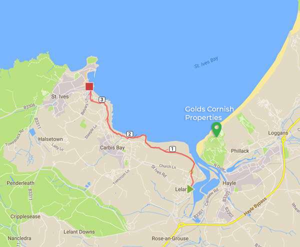
4 miles
Difficulty: Easy
From St Ives take the train to Lelant (the easiest bit!).
Walk back along The Saltings going left up Green Lane to the Church.
Take the footpath next to the church which passes over the golf course and the railway line to the Sand Dunes and Porthkidney Beach (Don't forget to duck if you hear someone shout "FORE").
Porthkidney Beach is a lovely place to stop for a swim in the summer but be sure to use the lifeguarded areas as there can be strong rip currents near the mouth to Hayle estuary.
Continuing, where the footpath crosses the railway line, turn left and from here getting back to St Ives is simply a case of keeping the sea to your right and taking the footpath.
The path will take you over the dunes, around Hawke's point crossing the railway line over another footbridge and then to Carbis Bay beach.
From here take the path below the gardens of the Carbis Bay Hotel and over the railway line again which will lead you onto Hain Walk and eventually Porthminster beach back in St Ives.
3 miles
Difficulty: Easy
This is a pretty circular walk along the coast path towards Zennor, turning inland at Hellesveor Cliffs before returning to St Ives, with an optional extension around the Island to turn it into a figure of eight.
Starting at Porthmeor Beach Car Park, join the Coastal Footpath past the Bowling Green with the sea on your right.
Continue along the footpath through the kissing gate at Clodgy Point, past Mans Head following the yellow way marks up the hill swinging slightly left by the stone walling.
Follow the coastal footpath (ignoring the right hand lower paths) for approximately one mile until you reach Hor Point and Hellesveor Cliffs which are marked with a National Trust sign.
Turn left up the track heading away from the sea. After approximately 300 yards turn left over the stile marked with a black and white post and follow the path heading back towards St Ives.
This path will then become Burthallan Lane, continue along this lane past the Garrack Hotel to the T junction at Alexandra Road.
Turn left and follow this road as it zig zags back towards Porthmeor, eventually heading down Porthmeor Hill to the car park where you started.
If you would like, you can then extend the walk by just over another mile or so to walk around the Island and back.
To do this continue on towards the beach and then on past The Tate Gallery.
Follow the road as it turns away from the beach and follow it left at Bumbles Tea room, past the Porthmeor Studios and St Ives School of Painting.
When you reach the Fish Pi Pottery turn left into Porthmeor Road follow the road as it turns right and then turn left down the vehicular access to the beach.
Before reaching the sand take the path back up again to The Island, and follow the path around the Island keeping St Nicholas Chapel on your right and the sea on your left.
Passing the National Coastwatch Institute lookout on your left take the path left which leads down to a red doggy bin marking a set of steps which will take you on to Porthgwidden beach.
At the beach stay on the walkway around the entire beach past the huts and cafe, then head back up another set of steps to head around the car park (with the car park on your right) in the direction of St Ives harbour.
Follow the path bearing right following the ornate lamp posts to head up the steps leading up to the St Ives Museum on your right.
From the top of the steps follow the road briefly to the left before taking the second turning on the right to head down Back Road East, and follow this road all the way back to Porthmeor Car Park.